

As mention previously in my first Lake District post (which is all about Skiddaw if you’re interested), this August, we decided to complete the three-hour journey up to the Lake District, to a small market town nestled in the northwest of the Lakes called Keswick. When planning our trip, the whole idea was that we were to tackle the toughest mountain on the first day as the weather outlook was far better, and this is how we ended up walking Skiddaw. Day two took us to Buttermere, a beautiful village nestled on the edge of Buttermere Lake. From here, we planned to walk to Scale Force, the largest waterfall in the Lake District with a 170ft drop, onwards up to Red Pike, High Stile and High Crag with a maximum peak of 807m.
Arriving in the pouring rain, we eventually plucked up the courage to venture out of the car and start the walk, assuming it would take around five hours. Setting off towards Crummock Water, the ground became exceptionally boggy accompanied by huge pools of water which covered the footpath for pretty much the entire first mile (my boyfriend took the opportunity to prove his masculinity by carrying me over since my boots weren’t actually waterproof). If we were ever to complete this walk again, it will certainly be on a sunny and dry day! Due to the excess water, the initial part of the walk towards Scale Force became delayed, and it took us a lot longer than expected. Despite this, the walk itself wasn’t difficult, it was fairly flat ground with a well-trodden footpath that you could probably walk in trainers if you wanted.
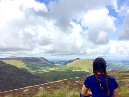
When we eventually navigated ourselves to Scale Force, nearly two hours had passed since we set off. Admittedly, we got a little lost in the overgrown vegetation and ended up walking the wrong way a couple of times, but we made it in the end! Scale Force waterfall is primarily made up of one larger drop with several smaller ones, and is tucked away in a gorge to the north side of Red Pike. The next battle would be walking up towards Red Pike. With my boyfriends horrendously poor map-reading skills, we did nearly end up walking in the opposite direction, into a completely different valley (I just want to state that I did point out the correct path but he didn’t listen), before some walkers informed him of the actual path we needed to take.
The next section of the walk took us up the Scale Force gorge, and this certainly was a difficult section. The path was steep and was made of red rocks (this is why Red Pike is called Red Pike) which on this day, were extremely wet and slippery. At some points you were climbing two-three metres at once, and looking back down you just prayed the grip on your shoes didn’t give in, because I certainly did not want to fall backwards! Further up this path when it did eventually level out, Scale Force was on your right and here enters one of the scariest moments I’ve endured! Scaling horizontally across a rock face with a 170ft waterfall drop behind you. Would I do it again? No chance! I’m terrified of heights but going forward seemed so much more preferable to going back down the path we’d came up. I was so thankful to get over that section and back onto normal grassland, leaving the waterfall and its slippery rocks behind was such a relief.
After this terrifying interval, the rest of the walk seemed like a blessing! The following path up to Red Pike was steep, but it was peaceful. As far as we could see, we were the only people in this part of the valley which is definitely an advantage of taking the path less travelled by. By the time we eventually summit-ed Red Pike, we’d already been walking for five hours and at this point we decided not to continue on our intended route, but instead come back down the side of Red Pike towards Buttermere Lake.
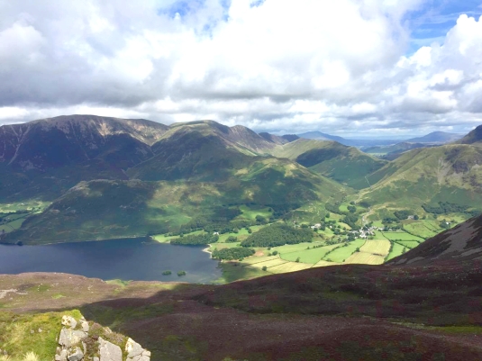
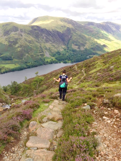
Although it took us five hours to get up, we managed to descend back to the car park in just over a couple of hours, with a small rest at Bleaberry Tarn. The descent wasn’t friendly, and I did feel for the people trying to get up it. The walk down included a long Scree Gully, which probably took close to 45 minutes to get down, it was steep and at points it was just easier to slide down than walk. After this it was stepping stones all the way down until Buttermere Lake, which could have been a pleasurable descent on a sunny day, but not so much on a rainy one, especially since at some points, the rocks were at a 60 degree angle which is not so fun to try and balance on! The views coming down this section were spectactular, almost as nice as the views at the top of Red Pike. I also enjoyed this section of the walk because it zig-zagged down to Buttermere, and eventually took us into a forest.
This was probably one of the most difficult walks I’ve ever tackled, and towards the end I was definitely flopping from lack of energy. Had the weather been nice, I think this walk could have been much much easier and would’ve knocked a couple of hours off the total walking time. Luckily day three of our Lake District trip was to be a nice gentle stroll around some waterfalls, and we definitely made a bee-line for the pub on this night, ready to devour 2,000 calories of well-deserved pub food and drink! I may or may not write about day three, I have a couple of nice photos to show, but we shall see! Do you have any nice Lake District experiences?


Looks beautiful!
LikeLiked by 1 person
Thanks! It was!
LikeLike
Beautiful pics..
LikeLiked by 1 person
Thank you 🙂
LikeLike
I love the lake district 😄 xo
LikeLiked by 1 person
Beautiful pictures Wonderful words. Nice work.
LikeLiked by 1 person
Thank you ❤️
LikeLike
Ufff seeing these pictures takes me down memory lane and reminds me how much I actually miss the UK despite all the rains.
LikeLiked by 1 person